


New models (such as the Hurricane Weather Research and Forecasting Model, left) are able to simulate hurricane structures as small as 1.2 miles across, improving predictions.

 |
New models (such as the Hurricane Weather Research and Forecasting Model, left) are able to simulate hurricane structures as small as 1.2 miles across, improving predictions. |
| Tuesday, July 28, 2:30 – 4:30 p.m. ET
To log in, click here and enter the passcode 20910. Call-in details will pop up on-screen after you log on. Please share your connection with other as space is limited. |
|
| Speakers
Rick Knabb (NOAA National Hurricane Center) Gerry Bell (NOAA Climate Prediction Center) Robert Atlas (NOAA Atlantic Oceanographic and Meteorological Laboratory) Steven Goodman (NOAA National Environmental Satellite, Data, and Information Service) Vijay Tallapragada (NOAA Environmental Modeling Center) Jeff Payne (NOAA National Ocean Service) Tom Knutson (NOAA Geophysical Fluid Dynamics Laboratory) Jim Kossin (NOAA National Centers for Environmental Information) Mel Landry (NOAA National Marine Fisheries Service Habitat Restoration Division) |
|
| Watch Webcast: |
(Right click and Save Link As) .wmv |
 |
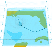
Comparing the three-day track forecast for Katrina in 2005 (left) with a recent re-forecast (right) shows how improvements in forecast technology and techniques over the past 10 years have led to more confidence in the forecast of hurricane track, as indicated by the smaller size of the forecast path (white area). |
ABSTRACTS: Rick Knabb (NOAA National Hurricane Center)
A Decade of Advances at the National Hurricane Center since Hurricane Katrina
The United States has not experienced the landfall of a major hurricane, defined as category 3 or stronger on the Saffir-Simpson Hurricane Wind Scale, since 2005. Nevertheless, several other hurricanes and tropical storms have come ashore and resulted in major impacts and loss of life in this country. Many of those impacts and losses have been due to water, with storm surge causing extensive damages in coastal areas and freshwater floods extending well inland. As exemplified by Katrina, storm surge poses a greater threat for large loss of life in a single day than any other weather-related hazard. Even prior to more recent storm surge events including Ike 2008 and Sandy 2012, the NHC has been working toward new storm surge products and warnings scheduled to be implemented operationally during the next couple of years. Work is also underway to be able to issue tropical storm warnings even prior to the formation of a tropical cyclone, with potential debut of this capability in 2017, so that even more timely watches and warnings can be issued for storms like Katrina that form close to the U. S. coast.
Gerry Bell (NOAA Climate Prediction Center)
Evolution of NOAA’s Atlantic Hurricane Season Outlooks Since 2005
NOAA’s seasonal hurricane outlooks for the North Atlantic basin are an official product of the Climate Prediction Center, and are made in collaboration with the National Hurricane Center and Hurricane Research Division. NOAA’s Atlantic hurricane season outlooks have evolved considerably since their inception in August 1998, with many advances occurring since 2005.
During the record 2005 Atlantic hurricane season, which included Major Hurricane Katrina, only statistical prediction tools were available to seasonal hurricane forecasters. Also, key research papers that subsequently led to large advances in our understanding and predicting of the climate patterns that control the hurricane season strength had not yet been published. Nonetheless, key indicators for an above-normal season in 2005 were well recognized, and NOAA’s August 2005 hurricane outlook alerted the public to “an extremely active season, with an expected seasonal total of 18-21 tropical storms (mean is 10), with 9-11 becoming hurricanes (mean is 6), and 5-7 of these becoming major hurricanes (mean is 2-3).” Concern for landfalling hurricanes was also especially high, with the outlook stating “Given the forecast that the remainder of the season will be very active, it is imperative that residents and government officials in hurricane-vulnerable communities have a hurricane preparedness plan in place.”
Since 2005, advances have occurred in all aspects related to the seasonal outlooks, including monitoring, understanding, statistical predictions, statistical/ dynamical hybrid model predictions, and purely dynamical model predictions. Some of these advances will be presented, and the current forecast model behind the outlooks will be addressed.
Robert Atlas (NOAA Atlantic Oceanographic and Meteorological Laboratory)
HFIP: NOAA’s Project to Improve the Accuracy of Hurricane Guidance
Since the Hurricane Forecast Improvement Project (HFIP) began in 2009, it has fostered a focused research and development community to build, demonstrate, and implement enhanced operational modeling to improve hurricane model forecasts in ten years. HFIP collaborators, including federal laboratories and academic partners, have made dramatic improvements in both hurricane track and intensity (up to 40%) model guidance. The program has leveraged new techniques including higher-resolution models (global and regional), enhanced model physics, improved data assimilation, better use of existing data sources to initialize regional hurricane models, and new post-processing techniques. This presentation will highlight the most significant contributions that have led to current success in achieving the mid-way goals for the ambitious 10-year HFIP program.
Steven Goodman (NOAA National Environmental Satellite, Data, and Information Service)
GOES-R – Our New Eye on Storms from Space
The next generation of GOES, the GOES-R series, with planned launch in 2016 offers improved spacecraft and instrument technology to provide more accurate, detailed and timely detection of tropical cyclones, severe storms, flash floods, volcanic eruptions, fires and other high impact environmental phenomena. The GOES-R capabilities used in tandem with radar, surface observations, and numerical models offer great potential to monitor and predict the evolution of storms and improve public safety. At the same time the mission offers significant opportunities and challenges in quickly creating, updating, and disseminating data and products in near real-time to produce more accurate forecasts and warnings. The Advanced Baseline Imager (ABI) will provide three times more spectral information, four times the spatial resolution, and more than five times faster temporal coverage than the current system with rapid scan imagery as often as every thirty seconds in mesoscale mode and at least every 5 min or 15 min (as opposed to the 7.5, 15 or 30 min data from today’s imager). Additional advancements over current GOES capabilities include continuous total lightning detection and mapping of in-cloud and cloud-to-ground flashes from the Geostationary Lightning Mapper (GLM) and increased dynamic range, resolution, and sensitivity imaging solar activity. The data from the ABI, GLM and space weather instruments will have a wide-range of uses and multiple societal benefits in areas such as weather and climate, energy, transportation, and commerce. This presentation will highlight the new capabilities that GOES-R will provide for monitoring tropical storms using recent examples of simulated and other proxy imagery.
Vijay Tallapragada (NOAA Environmental Modeling Center)
Advancements in Operational Hurricane Forecast Guidance from NCEP/EMC HWRF Modeling System: Progress in hurricane forecast improvements during the last decade since Hurricane Katrina
Although hurricane track forecasts have shown steady improvement over the years, intensity forecasts, which were rather stagnant until recently, started showing significant improvements in the past few years. This could primarily be attributed to more focused research, development, implementation and enhancement of advanced high-resolution atmosphere-ocean coupled hurricane modeling system known as the Hurricane Weather Research and Forecast (HWRF) model in operations at NCEP. The Hurricane Forecast Improvement Project (HFIP) established by NOAA in 2009 with ambitious goals of reducing track and intensity forecast errors by 20% in five years and 50% in ten years, apart from improved reliability and accuracy of hurricane forecast models, is the major driving force behind this steep step progress in hurricane intensity forecast guidance. The operational HWRF model was able to demonstrate steady and significant improvements in intensity forecasts since 2011, essentially reducing the intensity errors by about half and reaching the 5-year HFIP goals by 2015.
Hurricane Katrina is one of the costliest and deadliest hurricanes in the history of United States. As we are entering into its tenth anniversary, it is timely to review the state-of-the art of operational hurricane forecasting then and now. This presentation will illustrate the quality and skill of hurricane forecasts for Katrina using today’s state-of-the-art operational HWRF modeling system compared to the technology existed ten years ago, with emphasis on the scientific advancements accomplished, and the challenges we still face in predicting rapid changes in the hurricane intensity.
Jeff Payne (NOAA National Ocean Service)
Advancing Risk Communication and Management through Social Science and Technology
If experience is the best teacher, this nation has learned a lot over the past ten years. Katrina, Rita, and Sandy were harsh instructors, to say the least, but a larger percentage of the nation’s coastal communities are talking about the new normal – or more precisely, the lack of “normal” in terms of coastal hazard frequency, strength, and impacts. NOAA notes two truisms that continue to rise in importance: 1) everyone underestimates risk; 2) the time to prepare is before tragedy happens, when the skies are blue.
This presentation will address the ways in which coastal communities are taking a giant leap forward, as compared to ten years ago, to get citizens involved in making communities stronger. Many of these efforts use NOAA tools and technical assistance, including social science techniques, to increase public understanding and engagement and change the way people think about risk, coastal hazards, and what can be done. It’s a difficult conversation, but one that this nation is having with improved results.
Tom Knutson (NOAA Geophysical Fluid Dynamics Laboratory)
Hurricane Modeling and Prediction across Timescales at GFDL
NOAA’s Geophysical Fluid Dynamics Laboratory (NOAA/GFDL) is engaged in extensive numerical model development and research toward a predictive understanding of hurricane activity on timescales from hours to centuries. This work focuses on connecting fundamental research with improvements in prediction capability.
Recent key achievements include:
– Upgraded the GFDL regional hurricane operational model (resolution, physics, initialization) for the National Weather Service and U.S. Navy
– Development of an experimental dynamical seasonal hurricane hurricane prediction system, including prediction of regional-scale hurricane activity months and seasons in advance. Outputs are provided to NWS to help inform NOAA’s Seasonal Hurricane Outlook.
– Development of a Super High-Resolution Atmosphere Model (Super HiRAM) with two-way nesting capability to simulate and predict genesis of not only hurricanes but also supercell storms and possibly tornadoes within a unified regional-global modeling system.
– Development of a new high resolution global prediction system targeted for intense hurricane activity prediction (months to seasons) and climate change applications. This model appears to be currently the world’s leading model for dynamical simulation of the climatology and year-to-year changes of intense (Category 3-4-5) hurricane/typhoon activity.
Jim Kossin (NOAA National Centers for Environmental Information)
Past and Projected Poleward Migration of Typhoons
The average latitude where tropical cyclones (TCs) reach their peak intensity has been observed to be shifting poleward over the past 30 years, apparently in concert with the independently observed expansion of the tropics. This poleward migration is particularly pronounced and robust in the western North Pacific Ocean (WNP), and has lead to systematic increases and decreases, depending on region, in human exposure to TCs over the past 35 years. In particular, the poleward migration in the WNP has coincided with a decrease in TC exposure in the region of the South China Sea, including the Philippines, Vietnam, and Southern China, and an increase in exposure in the region of the East China Sea and Sea of Japan, including Taiwan, Japan, and Korea. Additionally, numerical projections of WNP TCs, as simulated with Coupled Model Intercomparison Project Phase 5 (CMIP5) models, demonstrate a continuing poleward migration and shifting regional human exposure into the 21st century under the RCP8.5 (“business as usual”) scenario.
Mel Landry (NOAA National Marine Fisheries Service Habitat Restoration Division)
Progress in Habitat Restoration in Coastal Louisiana since Katrina
In addition to providing rich habitat for one of the Nation’s most productive fisheries, Louisiana’s coastal wetlands act as a natural physical buffer helping to protect communities from the impacts of hurricane-induced storm surge. Katrina slammed into a Louisiana coast that had already lost over 1,900 square miles of protective coastal wetlands. In the wake of the storm, efforts to restore Louisiana’s coast were invigorated. NOAA and our partners have been restoring coastal wetlands in Louisiana for over two decades, but with the development of Louisiana’s 2007 and 2012 Coastal Master Plans, a new emphasis has been placed on prioritizing projects that maximize benefits to habitat and communities. NOAA and our partners’ efforts to restore the barrier islands of the Barataria Basin are a case study in the implementation of the goals set out in the Louisiana Master Plan. Of the 12 distinguishable barrier islands/headlands in the Barataria Basin, eight have been restored since 2005, and two are scheduled to begin construction this fall. These islands have been impacted by more recent storms such as Isaac in 2012, and have shown their resiliency. With predictions for continued subsidence and increased sea level rise, preserving and restoring coastal wetlands across the nation will be a critical component to preserving the economic integrity of coastal communities. Work conducted by NOAA in Louisiana provides a roadmap for achieving resiliency goals across our Nation. Image sources:
http://www.nnvl.noaa.gov/MediaDetail2.php?MediaID=105&MediaTypeID=1
http://www.emc.ncep.noaa.gov/gc_wmb/vxt/Keqin/HWRF_Animation/Cloud_Land_Track.gif
National Hurricane Center